(via TheNewswire)
 | |||||||||
 |  |  |  | ||||||
Sample and drill core analysis reinforces a near-surface copper porphyry and expanding Au-Ag-Te zone.
Prospecting and mapping at Deer Horn included 125 samples that were collected and submitted for assay. The program was managed by Technical Consultant and QP Dr.
“These results are highly encouraging,” said Groat. “The Main Te-
The assays were prepared by
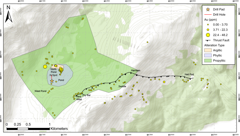
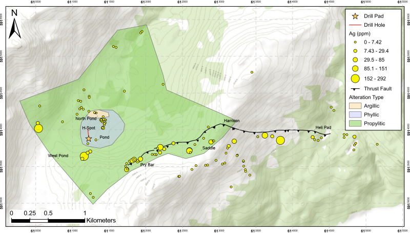
The six maps below show Cu, Mo, Au, Ag, Te, and W concentrations, along with alteration mineralogy characteristic of a porphyry system. The commodities Cu, Mo, Te, Au, and W are elevated towards the west of the 2023 sampling area. Ag values are elevated in both the east and west of the 2023 sampling area. These results expand the Au-Ag-Te zone towards the west of the property.
“The porphyry is likely the source of all the mineralization,” said Groat, who concluded that the mapping program confirmed the primary structure within the Deer Horn property is a large, E-W trending thrust fault. “Orientations appear consistent across several lithological units. This suggests the veins formed as a result of the same structural regime and are likely part of a larger ore-forming process that generated both the Deer
For more information about the results, clickhereto view a recent presentation
Due to extensive wildfires in the region, access to helicopters and crews was greatly limited for most of the season. As a result, one hole (FTEL-23-01, see map) was drilled to a depth of 357 ft at the Pond copper porphyry location. The major rock type in the hole is an altered granodiorite crosscut by multiple altered porphyritic andesite dikes. Propylitic veins are prevalent throughout the hole.
“The alteration mineralogy in the drill core suggests that we are above the ore zone in models of porphyry systems,” said Groat. “Pyrite is disseminated in minor to trace amounts and present in veins and fractures throughout the majority of the hole. Chalcopyrite, malachite, molybdenite, and magnetite are all observed sporadically in the core.”
Fourteen samples of select intervals of the drill core were submitted for assay. Interval 164 ft to 170 ft reported the highest Cu and Ag values at 204 ppm and 0.46 ppm, respectively. Two intervals, 7 ft to 13ft and 52.5 ft to 58 ft, report the highest Te value at 0.06 ppm. Interval 176.17 ft to 182 ft reported the highest Mo at 6.24 ppm. Interval 299 ft to 305 ft had the highest W at 5.9 ppm. Au was below the detection limit across the 14 samples.
Assays from Drill Hole FTEL-23-01 are summarized below:
Sample # | From (ft) | To (ft) | Interval (ft) | Au (ppm) | Ag (ppm) | Te (ppm) | Cu (ppm) | W (ppm) | Mo (pm) |
203101 | .08 | 7 | 6.92 | <0.005 | 0.14 | <0.05 | 20.0 | 1.8 | 2.54 |
203102 | 7.00 | 13 | 6.00 | <0.005 | O.24 | 0.06 | 62.6 | 2.1 | 4.47 |
203105 | 25.16 | 31 | 5.83 | <0.005 | 0.24 | <0.05 | 116.5 | 2.8 | 3.97 |
203109 | 46.5 | 52.5 | 6.00 | <0.005 | 0.21 | <0.05 | 80.2 | 2.8 | 3.09 |
203111 | 52.5 | 58 | 5.50 | <0.005 | 0.06 | 0.06 | 16.8 | 3.0 | 2.51 |
203115 | 75.5 | 81.5 | 6.00 | <0.005 | 0.31 | <0.05 | 106.5 | 2.0 | 2.73 |
203125 | 130 | 136 | 6.00 | <0.005 | 0.19 | <0.05 | 68.5 | 1.7 | 2.86 |
203127 | 142 | 146.5 | 4.50 | <0.005 | 0.27 | 0.05 | 110.5 | 2.2 | 3.89 |
203132 | 164 | 170 | 6.00 | <0.005 | 0.46 | <0.05 | 204.0 | 3.1 | 3.31 |
203134 | 176.2 | 182 | 5.80 | <0.005 | 0.09 | <0.05 | 131.0 | 2.0 | 6.24 |
203141 | 212 | 218 | 6.00 | <0.005 | 0.12 | <0.05 | 47.4 | 1.7 | 3.00 |
203157 | 299 | 305 | 6.00 | <0.005 | 0.07 | <0.05 | 13.1 | 5.9 | 1.32 |
203158 | 305 | 310 | 5.00 | <0.005 | 0.05 | <0.05 | 30.4 | 3.7 | 1.86 |
203159 | 310 | 315 | 5.00 | <0.005 | 0.04 | <0.05 | 21.7 | 5.0 | 1.62 |
Note: Drill Hole FTEL-23-01 has an Azimuth 354 degrees and an angle of -70 degrees, drilled to a depth of 357 feet. Assays were prepared by
Docherty noted that the drill, owned by
Click Image To View Full Size
Gold Sampling Results
Click Image To View Full Size
Silver Sampling Results

Click Image To View Full Size
Tellurium Sampling Results

Click Image To View Full Size
Copper Sampling Results
Molybdenum Sampling Results

Click Image To View Full Size
Tungsten Sampling Results

Click Image To View Full Size
Qualified Person
The Company’s disclosure of technical or scientific information related to the
About
First Tellurium’s unique business model is to generate revenue and value through mineral discovery, project development, project generation and cooperative access to untapped mineral regions in Indigenous territory with sustainable exploration.
Our Klondike tellurium-gold property in
|
On behalf of the board of directors of “Tyrone Docherty” President and CEO |
For further information please contact: 604.789.5653 tyrone@firsttellurium.com |
X/Twitter: |
Neither the Canadian Securities Exchange nor its regulations services accept responsibility for the adequacy or accuracy of this release.
Forward-looking information
All statements included in this press release that address activities, events or developments that the Company expects, believes or anticipates will or may occur in the future are forward-looking statements. These forward-looking statements involve numerous assumptions made by the Company based on its experience, perception of historical trends, current conditions, expected future developments and other factors it believes are appropriate in the circumstances. In addition, these statements involve substantial known and unknown risks and uncertainties that contribute to the possibility that the predictions, forecasts, projections and other forward-looking statements will prove inaccurate, certain of which are beyond the Company’s control. Readers should not place undue reliance on forward-looking statements. Except as required by law, the Company does not intend to revise or update these forward-looking statements after the date hereof or revise them to reflect the occurrence of future unanticipated event.
Copyright (c) 2024 TheNewswire - All rights reserved.
Copyright (c) 2024 TheNewswire - All rights reserved., source


