Highlights:
- Hole Bg22012 returned a significant intersection of 365.0 metres (“m”) of mineralization grading 0.88 % copper-equivalent (“CuEq”) or 1.06 gram per tonne (“g/t”) gold-equivalent (“AuEq”) (0.54 g/t gold (“Au”), 0.40 % copper (“Cu”), 2.0 g/t silver (“Ag”) and 35.3 ppm molybdenum (“Mo”)) starting at 41.0 m from surface to 406.0 m.
- Including 29.0 m grading 1.01 % CuEq or 1.22 g/t AuEq (0.60 g/t Au, 0.48 % Cu, 2.1 g/t Ag and 31.8 ppm Mo) from 87.0 m depth down-hole.
- And Including 64.0 m grading 2.62 % CuEq or 3.17 g/t AuEq (1.82 g/t Au, 1.04 % Cu, 4.6 g/t Ag and 66.5 ppm Mo) from 120.0 m depth down-hole.
- Including 30.0 m grading 4.00 % CuEq or 4.84 g/t AuEq (2.95 g/t Au, 1.47 % Cu, 6.2 g/t Ag and 63.8 ppm Mo) from 120.0 m depth down-hole.
- Holes Bg21009 and Bg21010 tested areas outside of the Beskauga Main deposit. Strong advanced argillic to argillic alteration and local zones of copper-gold mineralization in hole Bg21010 demonstrates the potential for concealed porphyry-style mineralization hosted within the thick volcano-sedimentary package that is separated from Beskauga Main by a prominent regional-scale NW-SE trending fault zone.
Diamond drilling is ongoing at Beskauga (Figure 1) and Beskauga South (Figure 2) with further assay results expected in the coming months.
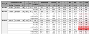
A summary of the results announced in this news release is outlined in the table below.
Table 1. Summary table for holes Bg21009, Bg21010 and Bg22012
Notes: Copper Equivalent (“CuEq”) grades reported for the drill holes at Beskauga were calculated using the following formula: CuEq % = Copper (%) + (Gold (g/t) x 0.8264) + (Silver (g/t) x 0.0107) + (Molybdenum (ppm) x 3.3333). Gold Equivalent (“AuEq”) grades reported for the drill holes at Beskauga were calculated using the following formula: AuEq g/t = Gold (g/t) + (Copper (%) x 1.2100) + (Silver (g/t) x 0.0129) + (Molybdenum (ppm) x 4.0334). Assumptions used for the copper and gold equivalent calculations were metal prices of
Results of Bg21009, Bg21010 and Bg22012:
Bg21009: (see Figure 1) was collared outside of the area covered by the current NI-43-101 Mineral Resource Estimate for Beskauga. It was designed to test a broad zone of demagnetization, identified in the airborne magnetics, at the southwestern margin of the monzodiorite intrusion (that has been drilled in Arras drill holes Bg21005 and Bg21008; refer to our press releases dated
The zone of demagnetization is also coincident with anomalous copper-gold-bismuth values in “KGK” (top of bedrock) drill holes. The upper portion of the hole intersected sodic (albite-hematite) altered diorite that has been overprinted by moderate to strong argillic (illite-smectite) alteration. The diorite lacks any significant copper-gold mineralization. The lower portion of the hole intersected the potassic altered monzodiorite intrusion, with a 62.0 m zone of weak mineralization grading 0.29 % CuEq intersected from a depth of 452 m down-hole. Although generally low-grade, occasional high tenor veins do occur, for example, 1 m grading 2.79 % CuEq (2.33 g/t Au, 47.2 g/t Ag, 0.35 % Cu and 26.8 ppm Mo) occur within the monzodiorite. Compared to the diorite that hosts the bulk of the known mineralization at Beskauga, the
monzonite intrusion hosts significantly higher Mo grades, with up to 2,850 ppm in this hole. Alteration in the monzodiorite comprises k-feldspar, secondary (“shreddy”) biotite, magnetite, Mg-rich chlorite, and epidote, with variable argillic overprint comprising illite and smectite localized near the contact with the diorite, as well as around faults and fractures (confirmed by Arras using TerraSpec SWIR/NIR spectroscopy).
Bg21010: (see Figures 1) was collared in an area immediately north of the current NI-43-101 Mineral Resource Estimate for Beskauga. The hole was designed to test a thick volcano-sedimentary package, separated from Beskauga Main by a prominent NW-SE orientated fault. The volcano-sediments contain the largest lobe of the Beskauga Main induced polarization (IP) anomaly, which remained un-drill-tested despite its proximity to the known mineralization at Beskauga. The hole was designed to drill through this chargeability high.
The volcano-sedimentary package intersected in this hole comprises mainly of andesite breccias and tuffs of andesitic composition that are iron oxide (hematite) flooded and variably advanced argillic to argillic (kaolinite-dickite-illite-smectite) altered (confirmed by Arras using TerraSpec SWIR/NIR spectroscopy). At depth the alteration transitions into a propylitic assemblage (chlorite-magnetite-epidote) with a weak advanced argillic to argillic overprint persisting throughout. The volcano-sedimentary package has been intruded by several 10 to 25 m wide, copper-gold mineralized dykes of dioritic composition. However, based on their trace element composition the diorite dykes are geochemically distinct from the diorite that hosts the bulk of the mineralization at Beskauga Main. Mineralization is localized within and proximal to these dioritic dykes and comprises of quartz-chalcopyrite ± bornite, molybdenite veins in the upper argillic altered part of the hole, transitioning to quartz-pyrite veins deeper in the hole.
Despite only modest zones of mineralization in this hole, the presence of a separate generation of mineralized diorites demonstrates the potential for concealed porphyry-style mineralization hosted within the thick volcano-sedimentary package. This is further supported by “KGK” (top-of-bedrock) drilling which returned > 1 g/t Au, > 1 % copper and highly anomalous bismuth values in this area. A prominent magnetic high immediately to the NE of hole Bg21010 remains un-drill tested.
Bg22012: (see Figures 1, 3 and 4) was collared 90 metres southwest from Bg21001 (973.2 m of mineralization grading 0.82 % CuEq; for further information see our press release dated
The hole started in moderately, to very strong, argillic altered diorite. The argillic alteration consists of intense kaolinite-dickite-illite-smectite with local silicification, before transitioning to illite-smectite with depth (confirmed by Arras using TerraSpec SWIR/NIR spectroscopy). Mineralization occurs as a mixture of quartz vein, fracture-controlled zones and hydrothermal breccias of tennantite, chalcopyrite, pyrite, magnetite (or hematite after magnetite) with minor molybdenite locally. From 120 metres depth, the hole entered an exceptionally high-grade zone of 64.0 m grading 2.62 % CuEq, including 30.0 m grading 4.00 % CuEq.
From 408 metres the hole entered a series of post-mineral basaltic dykes that have filled the NW-SE orientated fault zone, before re-entering into diorite characterized by variably argillic (illite-smectite) overprinted sodic (albite-hematite) alteration. From a depth of 576.3 m the hole entered the volcano-sediments that comprise primarily of fine-grained, propylitic (chlorite-magnetite-hematite-epidote) altered andesitic tuffs. Generally, the volcano-sediments are poorly mineralized, but several narrow zones of mineralization were intersected. Here mineralization consists of quartz-tourmaline ± pyrite-chalcopyrite veins with k-feldspar alteration halos and quartz-pyrite-chalcopyrite-molybdenite veins.
Figure 1. Location of the holes completed to date as part of Arras’ planned 30,000-metre drill program on the Beskauga Main deposit and wider area. The surface projection of the block model from the current NI-43-101 Mineral Resource Estimate is shown for copper. The inset map in Figure 2 below shows the location of Beskauga Main relative to Beskauga South.
Figure 2. Location of the holes completed to date at the Beskauga South area, located approximately 3.2 kilometres SSW from the Beskauga Main deposit, and outside of the current NI-43-101 Mineral Resource Estimate. The inset map shows the location of Beskauga South relative to Beskauga Main.
Figure 3. Cross-section showing hole Bg22012 in relation to several historical holes drilled by Copperbelt. Also shown are grade contours based on the Beskauga block model for copper (only) developed for the purposes of the current Mineral Resource Estimate for Beskauga (for further details, please see Arras’ press release on
Figure 4. Cross-section showing hole Bg22012 in relation to several historical holes drilled by Copperbelt. Also shown are grade contours based on the Beskauga block model for gold (only) developed for the purposes of the current Mineral Resource Estimate for Beskauga (for further details, please see Arras’ press release on
Drill Program: In
In addition to testing the extents of the Beskauga deposit, the drill program is also targeting a series of previously undrilled targets in the wider area. These wider targets are supported by both ground and airborne geophysics, as well as in-situ geochemistry, derived using “KGK” drilling (a drilling method akin to 'wet' reverse circulation drilling, that recovers a 1 to 3 m core sample from the top of the underlying bedrock which is used by Arras to efficiently map lithology, alteration, and geochemistry across the property beneath overburden).
For both the diamond and KGK drilling, Arras has been using the local company “Tsentrgeolsemka LLP”. Arras later changed drilling contractors to “GRK Iskander Ltd” and mobilized a diamond drill rig with the capacity to drill deeper holes, if required, as well as improved core orientation through triple tube core barrel drilling.
About the Beskauga Deposit: The Beskauga deposit is a gold-copper-silver deposit with an “Indicated” Mineral Resource of 111.2 million tonnes grading 0.49 g/t gold, 0.30% copper, and 1.3 g/t silver for 1.75 million ounces of contained gold, 333.6 thousand tonnes of contained copper, and 4.79 million ounces of contained silver and an “Inferred” Mineral Resource of 92.6 million tonnes grading 0.50 g/t gold, 0.24% copper and 1.1 g/t silver for 1.49 million ounces of contained gold, 222.2 thousand tonnes of contained copper, and 3.39 million ounces of contained silver. The constraining open pit was optimized and calculated using a Gross Metal Value (“GMV”) cut-off of
Based on exploration undertaken to date, the Beskauga deposit is interpreted by Arras to represent a gold-rich porphyry copper-gold deposit that has been overprinted by high-sulfidation epithermal mineralization, either through telescoping or due to clustering of multiple porphyry centers within the Beskauga license that have superimposed alteration and mineralization upon earlier phases. Beskauga is located within the highly under-explored Bozshakol-Chingiz Volcanic Arc, which hosts KAZ Minerals’ Bozshakol porphyry Cu-Au mine only 130 km west of Beskauga. Bozshakol is one of the largest copper resources in
Contrary to many porphyry copper deposits being developed in other jurisdictions globally, the Beskauga project, located only 350 metres above sea-level, benefits from excellent modern infrastructure and accessibility. The region is mining-friendly and hosts several large-scale mining operations. Arras’ operations are based out of the nearby mining town of Ekibastuz, which services the largest coal mine in
Assay and QAQC Procedures: On receipt from the drill site, the diamond drill core was systematically logged for geological attributes, photographed and sampled at Arras’ operational base in the town of Ekibastuz,
After drying samples were crushed by ALS to >70% passing below 2 mm and split using a riffle splitter. 250 g splits were pulverized to 85 % passing below -75-microns. A 30 g split of the pulp was analyzed for gold content by fire assay with an Atomic Absorption Spectroscopy (AAS) finish (ALS method: Au-AA25™) at ALS Karaganda. A second pulp split was then air freighted to ALS Loughrea and analyzed for 48 elements by Inductively Coupled Plasma Mass Spectrometry (ICP-MS) after four-acid digestion on a 0.25 g aliquot (ALS method: ME-MS61™). Any samples exceeding 1% copper were re-analyzed using a 4-acid digest ICP-MS ore grade method (ALS method: Cu-OG62™).
Qualified Person: The scientific and technical disclosure for the
On behalf of the Board of Directors
"Tim Barry"
Chief Executive Officer and Director
INVESTOR RELATIONS:
+1 604 687 5800
info@arrasminerals.com
Further information can be found on the Company’s website https://www.arrasminerals.com or follow us on LinkedIn: https://www.linkedin.com/company/arrasminerals or on
About
Arras is a Canadian exploration and development company advancing a portfolio of copper and gold assets in northeastern
Cautionary Note to U.S. Investors concerning estimates of Measured, Indicated, and Inferred Resources: This press release uses the terms “measured resources”, “indicated resources”, and “inferred resources” which are defined in, and required to be disclosed by, NI 43-101. The Company advises U.S. investors that these terms are not recognized by the
Disclosure of “contained ounces” in a resource is permitted disclosure under Canadian regulations, however the
Cautionary note regarding forward-looking statements: This news release contains forward-looking statements regarding future events and Arras’ future results that are subject to the safe harbors created under the
Graphics accompanying this announcement are available at
https://www.globenewswire.com/NewsRoom/AttachmentNg/0dbae2b7-06f7-4df2-a7aa-440c523d449a
https://www.globenewswire.com/NewsRoom/AttachmentNg/366348f0-5d3a-4360-b671-e8da030552ee
https://www.globenewswire.com/NewsRoom/AttachmentNg/401b3bbf-f3cb-4efd-9dbd-2eafcc4f5ec2
https://www.globenewswire.com/NewsRoom/AttachmentNg/eca21e7f-7a82-44cd-bbf2-f2fbdbb8ac34
https://www.globenewswire.com/NewsRoom/AttachmentNg/9815d2d3-bcca-479a-b34c-444de5e2f521

![]()
Table 1.
Summary table for holes Bg21009, Bg21010 and Bg22012
Figure 1.

Location of the holes completed to date as part of Arras’ planned 30,000-metre drill program on the Beskauga Main deposit and wider area. The surface projection of the block model from the current NI-43-101 Mineral Resource Estimate is shown for copper. The inset map in Figure 2 below shows the location of Beskauga Main relative to Beskauga South.
Figure 2.
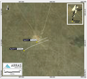
Location of the holes completed to date at the Beskauga South area, located approximately 3.2 kilometres SSW from the Beskauga Main deposit, and outside of the current NI-43-101 Mineral Resource Estimate. The inset map shows the location of Beskauga South relative to Beskauga Main.
Figure 3.
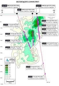
Cross-section showing hole Bg22012 in relation to several historical holes drilled by Copperbelt.
Figure 4.
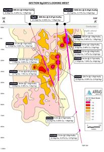
Cross-section showing hole Bg22012 in relation to several historical holes drilled by Copperbelt.
2023 GlobeNewswire, Inc., source


