“For the first time, we have demonstrated that gold is present in this essentially unexplored extension of the Red Lake Greenstone Belt. Using the knowledge gained from our Phase 1 drill program, we look forward to vectoring towards additional targets this winter as we’ve identified several compelling and significantly sized target areas. To date we have sparsely tested only a 5.6km strike length, a small part of the ~18km of prospective target strike length at RLX. We believe that our RLX project has all the attributes to host gold mineralization in a gold camp that continues to yield new gold discoveries and look forward to results from this winter’s drill program.” stated Solstice Chairman,
Project Background:
RLX hosts a road-accessible, 18km-long largely unexplored extension of the Red Lake Greenstone Belt (“RLGB”), located ~27 km north of the community of
Highlights from Phase 1:
In 2022, Solstice completed 5,323m of diamond drilling in 11 drill holes. These holes tested a 5.6km corridor in the Central Target area of RLX. This total includes one lost drill hole which was abandoned prior to testing its target. Gold-bearing quartz-sulphide veining was intersected in mafic rock units overlying iron formation in two drill holes. Intensely altered zones (“ALT”), structurally above the mafic units noted above are associated with an extensive, moderate electro-magnetic (“EM”) response comprising several biotite-sericite, +/- potassium feldspar flooded intervals (9m-36m core length) which obliterate primary rock types. Gold values to date in these units are low but enrichment in some pathfinder elements (Ag, Pb, Zn) indicate their potential prospectivity. 2022 drill results confirm that the RLX property is underlain by the northern extension of volcanic rocks of the Red Lake Greenstone Belt as documented at the Sidace gold deposit located approximately 12.5 km to the southwest (Evolution Mining 53.3% / Pacton Gold 46.7%). Assay results presented here represent the first reported gold within the RLX volcanic package. For additional information, please refer to our news release “Solstice Provides Red Lake Exploration Update and Announces Winter Drilling at RLX” dated
Phase 2 Program:
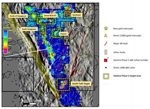
Many large and prospective areas of RLX shown in Figure 1, are best accessed in the winter due to the presence of lake and/or swamp. Winter targets have some of the strongest electro-magnetic (“EM”) response and structural complexity at RLX. Drilling has commenced at the South Fold target area.
Figure 1. RLX property showing new gold and historical (Dome Exploration, 1980) intercepts, completed Solstice drill holes and Phase 2 target areas. Base map is 220-240m (below surface) resistivity slice from 3D EM inversion modeling (Emergo SCI). 9* denotes hole lost due to technical reasons.
Target areas include:
- A mapped fold in the South Fold Target within altered mafic volcanics and iron formation with strong EM response. Folding post-dates regional folding in the area and is associated with large-scale NE-trending faults (Figure 1). Solstice interprets this area to be the northeastern extension of the East Bay Fault (“EBF”). In the core of the
Red Lake camp, the EBF is a fundamental regional structure with associated gold mineralization along much of its length. - Follow up of elevated gold and alteration in Phase 1 areas (South Nungesser target)
- Areas where shallow drilling using small, 18mm diameter core by Dome exploration in 1980 documented elevated gold* (Dome B6 and B7 targets).
- Additional target areas as shown in Figure 1 guided by observations from current drilling, gold in humus soils and geophysical modeling.
*In addition to newly identified gold in volcanic rocks, previous drilling in 1980 by Dome Exploration* reported elevated intrusive-hosted gold in two shallow holes drilled on
South Fold Target Area
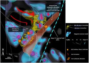
This area (Figure 2) is defined by a NE trending fold cut by regional-scale NE-faults. Mapping in this area has identified epidote and carbonate altered mafic volcanic flows and flow breccias with local intercalated exhalite units. These are likely correlated to mafic volcanics in the main RLGB. The area exhibits strong Bi-Pb-Mo and Au-Ag-Sb soil anomalies. EM inversion modeling identifies three main target areas which display increasing conductivity with depth. Drilling in this area is designed to test all three attributes, geological, geochemical, and geophysical.
Figure 2. RLX F3 South Fold 3D view of target area (plan view) with interpreted faults sets and selected geological units. EBF is the
Northern Target Area
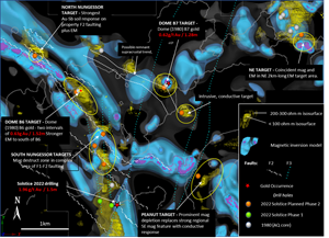
Targets other than the South Fold area are shown in Figure 3. The main limb of the RLX greenstone belt, which occupies the western half of Figure 3, forms a flexure related to extensive F2 faults cut by later F3 faults. Solstice drill hole 22-07, which returned 1.96g/t Au over 1.5m (see news release dated
An additional four holes will test remaining targets in the eastern part of Figure 3. These include areas of EM associated with magnetic depletion which are related to a NE-trending F3 fault (Peanut Target), strong EM response with associated magnetic response (NE Target) and previous gold documented by Dome Exploration (B7 Target).
Figure 3. RLX Northern targets 3D view (plan) with interpreted faults sets and planned drill holes.
*Dome Exploration (1980, “Dome”) results are reported in
Dome reported a total of 12 AQ (18mm diameter) drill holes in the area for a total of 1198.3m (average hole length 87m after subtracting overburden). Of these, four were drilled in the wrong direction and two drill holes were sampled but no assays were reported. Remaining holes were sparsely sampled but returned trace gold. Values reported in Dome drill logs were converted from imperial measurement and dwt gold using 1.55 dwt = 1g/t..
1Lewis, S.O. 2021. Deep tapping seismic structure in the
2
3 Stone, D. and Good D. 1990. Precambrian geology,
About
Solstice is an exploration company with quality, district-scale gold projects in established mining regions of
Solstice is committed to responsible exploration and development in the communities in which we work. For more details on our core properties or the recently acquired royalty and property portfolio, please see visit our website at www.solsticegold.com.
Neither
On Behalf of
For further information on
Phone: (604) 283-7234
info@solsticegold.com
Forward-Looking Statements and Additional Cautionary Language
This news release contains certain forward-looking statements (“FLS”) including, but not limited to the targeting of two main areas for Phase 2 drilling at RLX, the inclusion of ice drilling to optimize access to targets, that the geological and structural setting at RLX is highly prospective for gold mineralization, and the testing of specified targets in Phase 2. FLS can often be identified by forward-looking words such as “approximate or (~)”, “emerging”, “goal”, “plan”, “intent”, “estimate”, “expects”, “potential”, “scheduled”, “may” and “will” or similar words suggesting future outcomes or other expectations, beliefs, plans, objectives, assumptions, intentions or statements about future events or performance. There is also no guarantee that continued exploration at Solstice exploration projects, all of which are at an early stage of exploration, will lead to the discovery of an economic gold deposit. In respect of the FLS, the Company has made certain assumptions that management believes are reasonable at this time. The assumptions include conditions, including weather, will permit scheduled drilling and that the Company will have sufficient capital to execute it’s exploration activities. However, there can be no assurance that such assumptions and statements will prove to be accurate and actual results could differ materially from those anticipated in such statements. Factors that could cause actual results to differ materially from any FLS include, but are not limited to, unforeseen delays related to drilling, the future impacts of the COVID 19 pandemic and government response to such pandemic, the ability of the Company to raise capital, delays in obtaining or failures to obtain required TSXV, governmental, environmental or other project approvals, inability to locate source rocks, inflation, changes in exchange rates, fluctuations in commodity prices, delays in the development of projects, regulatory approvals, changes in national and local government, legislation, taxation, controls, regulations and political or economic developments, risks and hazards associated with the business of mineral exploration, the speculative nature of mineral exploration and development, title to properties and other factors. FLS are subject to risks, uncertainties and other factors that could cause actual results to differ materially from expected results.
Potential shareholders and prospective investors should be aware that these statements are subject to known and unknown risks, uncertainties and other factors that could cause actual results to differ materially from those suggested by the FLS. Shareholders are cautioned not to place undue reliance on FLS. By their nature FLS involve numerous assumptions, inherent risks and uncertainties, both general and specific that contribute to the possibility that the predictions, forecasts, projections and various future events will not occur. Solstice undertakes no obligation to update publicly or otherwise revise any FLS whether as a result of new information, future events or other such factors which affect this information, except as required by law.
Photos accompanying this announcement are available at
https://www.globenewswire.com/NewsRoom/AttachmentNg/62b07ac5-acae-4159-bdac-83e2844ad275
https://www.globenewswire.com/NewsRoom/AttachmentNg/a52879ac-8ee0-4898-9917-cb26b539650d
https://www.globenewswire.com/NewsRoom/AttachmentNg/971069ac-e6f6-4d5a-8ee3-e7f11bfa3a4e

![]()
Figure 1
RLX property showing new gold and historical (Dome Exploration, 1980) intercepts, completed Solstice drill holes and Phase 2 target areas. Base map is 220-240m (below surface) resistivity slice from 3D EM inversion modeling (Emergo SCI). 9* denotes hole lost due to technical reasons.
Figure 2
RLX F3 South Fold 3D view of target area (plan view) with interpreted faults sets and selected geological units. EBF is the East Bay fault.
Figure 3
RLX Northern targets 3D view (plan) with interpreted faults sets and planned drill holes.
2023 GlobeNewswire, Inc., source


