Highlights include:
- Highest grade intercept reported to date at Mirage with 3.28% Li2O over 10.6 meters in drill hole MR-23-26 at a vertical depth of 50 meters.
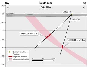
- Shallow intercept of 2.92% Li2O over 14.0 meters in drill hole MR-23-19 at a vertical depth of 46 meters.
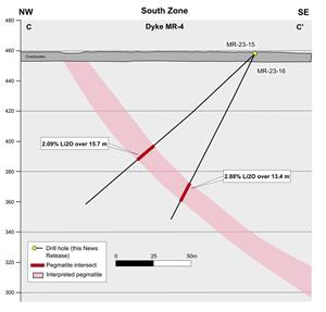
- 2.88% Li2O over 13.4 meters in drill hole MR-23-16 at a vertical depth of 86 meters.
- High-grade (>2.0% Li2O) mineralization has now been reported in 9 holes in MR-4 along the entire strike length drilled to date.
- MR-4 has been traced by drilling over a strike length of 600 meters and remains open to the northeast and at depth.
- Assays are pending for a further 10 drill holes (MR-23-27 to MR-23-36) completed during the fall 2023 program.
Table 1: Highlights from Maiden Drilling Program at MR-4
| Hole ID | Zone | Dyke | From (m) | To (m) | Length (m) | Li2O% | Ta2O5 (ppm) |
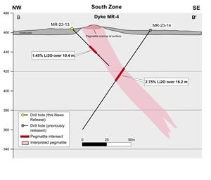
| MR-23-13 | South | MR-4 | 25.3 | 35.7 | 10.4 | 1.45 | 171 |
| MR-23-14* | South | MR-4 | 46.5 | 62.7 | 16.2 | 2.75 | 98 |
| MR-23-15 | South | MR-4 | 91.3 | 104.7 | 15.7 | 2.09 | 49 |
| MR-23-16 | South | MR-4 | 95.9 | 109.3 | 13.4 | 2.88 | 86 |
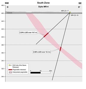
| MR-23-17 | South | MR-4 | 76.0 | 90.1 | 14.1 | 2.24 | 65 |
| MR-23-18 | South | MR-4 | 87.8 | 100.1 | 12.3 | 2.06 | 112 |
| MR-23-19 | South | MR-4 | 68.1 | 82.1 | 14.0 | 2.92 | 70 |
| MR-23-20 | South | MR-4 | 76.9 | 84.4 | 7.5 | 1.55 | 97 |
| MR-23-21 | South | MR-4A | 70.9 | 73.0 | 2.1 | 2.23 | 83 |
| MR-23-25 | South | MR-4 | 44.7 | 53.6 | 9.0 | 2.57 | 77 |
| MR-23-26 | South | MR-4 | 49.9 | 60.4 | 10.6 | 3.28 | 166 |
*Previously reported in
Mr.
Figure 1: Surface Map of the
South Zone Drilling
Nine of the ten holes drilled on the MR-4 dyke intersected high-grade (>2.0% Li2O) spodumene bearing pegmatite with excellent continuity and widths. The true thickness is estimated at 95% of the core length. MR-4 has now been drilled from surface to a shallow depth above 100 meters vertical and over a strike length of more than 600 metres. The dyke follows a stratigraphic contact between metasediments and metabasalts dipping southeast at a moderate angle of 45 degrees. The dyke’s surface projection is characterized by a narrow topographic depression and outcrops along a portion of its strike extent. Drill holes MR-23-21 and MR-23-22 (no pegmatite intersection in latter), both collared at the SW extremity of the current program, did not intersect a dyke at the contact potentially suggesting a pinch-out of the MR-4 dyke in this area. However, the presence of a thin, mineralized dyke in the metabasalt indicates that the
Two drill holes (MR-23-23 and -24), located 350m south from the initial pegmatite outcrop discovery for MR-4, tested the down-dip projection near the SW end but did not reach the stratigraphic contacts. Both holes were stopped short of their target near the end of the fall drilling season to allow for completion of the program and will be extended during the winter 2024 drilling campaign.
Figure 2: Cross Sections A to A’ Along Dyke MR-4
Figure 3: Cross Sections B to B’ Along Dyke MR-4
Figure 4: Cross Sections C to C’ Along Dyke MR-4
Figure 5: Cross Sections D to D’ Along Dyke MR-4
Figure 6: Cross Sections E to E’ Along Dyke MR-4
QAQC
All drill core samples were collected under the supervision of BRW employees and contractors. The drill core was transported by helicopter and by truck from the drill platform to the core logging facility in Val-d’Or. Each core was then logged, photographed, tagged, and split by diamond saw before being sampled. All pegmatite intervals were sampled at approximately 1m intervals to ensure representativity, and ¼ core splits were inserted regularly as duplicates. Samples were bagged; blanks and certified reference materials for lithium were inserted at regular intervals. Groups of samples were placed in larger bags, sealed with numbered tags, in order to maintain a chain of custody. The sample bags were transported from the BRW contractor facility to the ALS laboratory in Val-d’Or. All sample preparation and analytical work was performed by ALS. Samples were crushed in order for 70% of the material to pass through a 2mm screen (method CRU-31), a riffle split was made of a 1,000g sub-sample (SPL-21), and the split sample pulverized (PUL-31) to obtain more than 85% of the material inferior to 75µm. A 0.2g sub-sample of the pulverized fraction was dissolved in a sodium peroxide solution, prior to lithium analysis by ICP-AES according to the ALS method ME-ICP82b. All results passed the QA/QC screening at the lab and all inserted standard and blanks returned results that were within acceptable limits. All reported drill intersections are calculated on the basis of a lower cutoff grade of 0.10% Li2O, with maximum internal dilution of 1 meter. Host basalts adjacent to the dykes grade up to 0.3% Li2O but were excluded from the reported intersections. All drill hole collar, orientation and inclination data are available on the Company’s web site.
Clarification to Previously Announced 1Minerals Corp. Option Agreement
Under the terms of the Option Agreement with 1Mineral dated
North Shore Lithium Project Update
In
Qualified Person
The scientific and technical information contained in this press release has been reviewed and approved by Mr.
About
Investor Relations/information
Mr.
Cautionary Statement on Forward-Looking Information
This news release contains "forward-looking information" within the meaning of applicable Canadian securities legislation based on expectations, estimates and projections as at the date of this news release. Forward-looking information involves risks, uncertainties and other factors that could cause actual events, results, performance, prospects and opportunities to differ materially from those expressed or implied by such forward-looking information. Factors that could cause actual results to differ materially from such forward-looking information include, but are not limited to, delays in obtaining or failures to obtain required governmental, environmental or other project approvals; uncertainties relating to the availability and costs of financing needed in the future; changes in equity markets; inflation; fluctuations in commodity prices; delays in the development of projects; the other risks involved in the mineral exploration and development industry; and those risks set out in the Corporation’s public documents filed on SEDAR at www.sedar.com. Although the Corporation believes that the assumptions and factors used in preparing the forward-looking information in this news release are reasonable, undue reliance should not be placed on such information, which only applies as of the date of this news release, and no assurance can be given that such events will occur in the disclosed time frames or at all. The Corporation disclaims any intention or obligation to update or revise any forward-looking information, whether as a result of new information, future events or otherwise, other than as required by law. Neither the
Photos accompanying this announcement are available at:
https://www.globenewswire.com/NewsRoom/AttachmentNg/7e261593-57da-4538-8f0c-3a03ccf16983
https://www.globenewswire.com/NewsRoom/AttachmentNg/b0ec1961-fa06-42fc-b5b2-f382cdb22a8c
https://www.globenewswire.com/NewsRoom/AttachmentNg/8fbd5233-a2a4-4833-97a3-374d71b8010f
https://www.globenewswire.com/NewsRoom/AttachmentNg/a5abd7c9-35cc-48b3-90b9-ee8eed8e0898
https://www.globenewswire.com/NewsRoom/AttachmentNg/32769e40-505d-44d5-af32-78bd7bbe46bb
https://www.globenewswire.com/NewsRoom/AttachmentNg/74a54aa8-6fe1-4f5f-a68c-0a07cf36249c

![]()
Figure 1
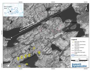
Surface Map of the Mirage Project and Drill Holes Completed to Date
Figure 2

Cross Sections A to A’ Along Dyke MR-4
Figure 3
Cross Sections B to B’ Along Dyke MR-4
Figure 4
Cross Sections C to C’ Along Dyke MR-4
Figure 5
Cross Sections D to D’ Along Dyke MR-4
Figure 6
Cross Sections E to E’ Along Dyke MR-4
2023 GlobeNewswire, Inc., source


