(via TheNewswire)
 | |||||||||
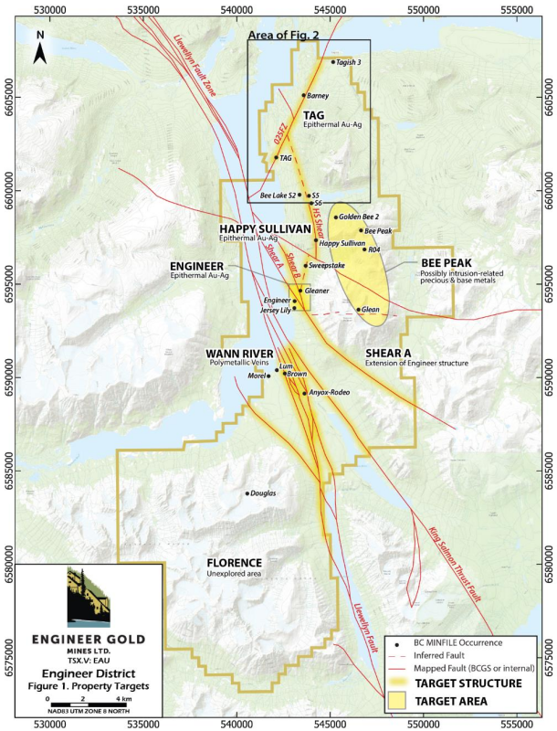
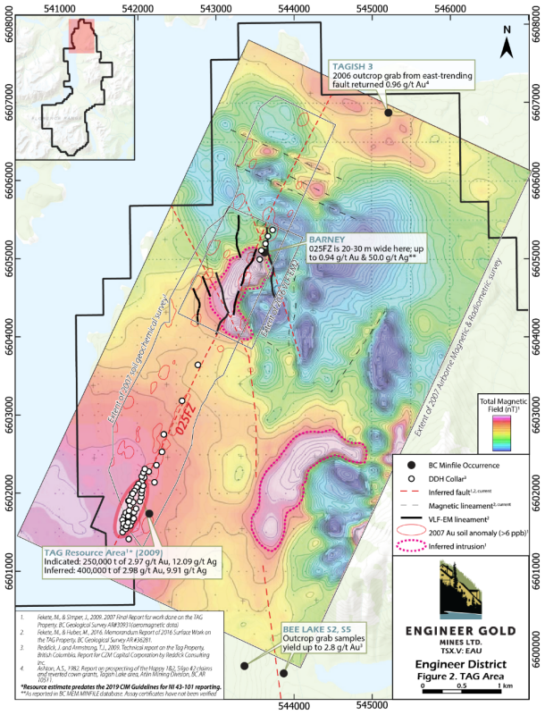
Mineralization in theTAGarea occurs along a NNE-trending shear zone termed the025FZ, which can be traced for 6.2 km across the northern portion of the
Since its discovery in 1987, the TAG area saw limited exploration until 2006, when
The authors of the technical report advised that potential exists for finding additional Au-Ag mineralization both below the current resource and along-strike and recommended the use of Induced Polarization (“IP”) surveys to refine targets for further drilling.
Click Image To View Full Size
In 2016,
The 2007 airborne survey also identified two probable intrusions, comprising kidney shaped magnetic highs with coincident elevated potassium counts (Fekete & Simper, 2009; Fig. 2). At Barney, drilling has confirmed that this geophysical feature represents a quartz-diorite stock, spatially and possibly genetically associated with mineralization. Previous workers have suggested that mineralization at Barney may represent an intrusion-related Au system or a deeper-seated extension of the TAG epithermal system (Pautler, 2021). The second geophysical feature, ~3 km south of Barney and 1.5 km east of Tag, has not yet been followed up.
In addition to the geophysical targets in the TAG area, strong Au-As-Sb soil geochemical anomalies delineate the 025FZ and occur sporadically on the periphery (Fekete & Simper, 2009; Fig 2). Prospecting and shallow trenching of the numerous geophysical and geochemical targets in the TAG area are recommended, to be followed by localized resistivity / IP surveys in preparation for drilling (Dubé, 2016).
**Resource estimates cited in this release predate the 2019 CIM Guidelines for NI 43-101 reporting and are historical in nature.
Click Image To View Full Size
References
Davies Justason , 2007a. Technical report 2006 reconnaissance exploration program on theTagish #3 mineral tenure. BC AR 28930.Dubé, J. 2016.
Technical Report VLF-EM Ground Survey , Tagish Property. Prepared by Dynamic Discovery Geoscience forTaku Gold Corp. Within BC Geological Survey AR #36281.Fekete, M., Simper, J., 2009. 2007 Final Report for work done on the TAG Property. BC Geological Survey AR #30931.
Fekete, M., Huber, M., 2016. Memorandum Report of 2016 Surface Work on the TAG Property. Operated by
Taku Gold Corp. BC Geological Survey AR #36281.Reddick, J. and
Armstrong , T.J. 2009. Technical report on the Tag Property,British Columbia . Report forCZM Capital Corporation byReddick Consulting Inc.
Qualified Person
The technical content of this news release has been reviewed and approved by
About
Engineer Gold Mine:The historic Engineer Gold mine is a narrow vein past producing underground gold mine with an Inferred Mineral Resource of 41,000 t grading 19.0 g/t gold for 25,000 oz contained gold. The resource uses a cutoff grade of 5 g/t Au and assumes a 1m minimum mining width, which is similar to historical mining. It includes all material inside the mineralized shoots and is based on the payability (stope) limits. Within this resource is a higher-grade core of 14,000t grading 52.5 g/t gold (25 g/t gold Cut-Off) containing 23,600 oz contained gold. The resource grade was reconciled to a bulk tonnage sample which contained 175 tonnes at 23.9 g/t Au which is 16% higher than the resource grade of 20.6 g/t Au for the Engineer portion of the resource. This is considered acceptable for a nuggety gold deposit and exemplifies the potential conservatism of the 2018 resource. This resource estimate was initially calculated by
Note that this resource estimate predates the 2019 CIM Guidelines for NI 43-101 reporting. The
company has done no further work to confirm this historical resource.
Tag Property:The 1,070-hectare Tag property covers the 025 or Main zone, which contains an historical mineral resource estimate including 250,000 tonnes of Indicated material at average grades of 2.97 g/t Au and 12.09 g/t Ag, and an Inferred resource of 400,000 tonnes at average grades of 2.98 g/t Au and 9.91 g/t Ag. The resource estimate was calculated using the polygonal method with vertical section at 50m spacing, and grades composited over a minimum length of 2.0 meters. The Au was capped at a value of 4 g/t and Ag was capped at 25 g/t. Underground mining was assumed with all material having a minimum composited length of 2m, within the interpreted shapes and above the cutoff assumed to be amenable to underground mining. The cut-off grade used was 3.0 g/t gold equivalent, calculated with a silver to gold ratio of 59.927. This historical resource was published as an NI 43-101 report filed on SEDAR entitled "Technical Report on Resource Estimates for the Tag Property,
On Behalf of the Board of Directors
“Christopher Huggins”
President & CEO
Tel: 604.968.4844
chris@engineergoldmines.com
Cautionary Notes
Neither the
Copyright (c) 2023 TheNewswire - All rights reserved.
Copyright (c) 2023 TheNewswire - All rights reserved., source


